Wednesday, October 30, 2013

0216 - Communicating interpretations

I come back to Santa Vitoria virtual reconstitution.


I definitely do not agree with it. There is no evidence of a bank inside the ditch. If there was a bank, some pits would have been covered by it; the inside area would have been highly restreated and, most important, there would have been evidences of erosion inside the ditch from a bank built with the geological material. Instead, we have inside the ditch layers of structured depositions and occupation features.

But my point here is that the impact on public opinion of words and pictures is not the same. I want to argue that drawing a scene is more powerful than just describe it by words. Our society is, more than ever, dependent on visual senses. It is easier to memorize an image than a written discourse.

That should give a higher sense of responsibility to the visual reconstitutions of archaeological sites, and in this particular context, of ditched enclosures. What might be presented as hypothesis in discourse seems to be a certain fact when presented in a drawing or animation.

In time, written things became more valued than spoken ones. Today images seem to have a lead. And where discourse might face a doubt, image tends to receive uncritical adherence.  

I don’t know if the readers of this blog agree with this, but I think that we should have this in mind when we decide to use visual representations of our ideas for these prehistoric sites (or any other sites).

Monday, October 28, 2013

0215 – Contenda and Santa Vitória

The recently discovered ditched enclosure of Monte da Contenda (Valera and Pereiro, 2013) through Google Earth, just 4,5 km from Santa Vitória ditched enclosure, raises some interesting questions, just like other enclosures that have been recently identified closer to each other (I remember the case of Salvada and Monte das Cabeceiras 2).

Monte da Contenda has at least three ditches, probably of patterned sinuous design, just like Santa Vitoria. It is in a slope facing south. And behind that horizon is Santa Vitoria.

Monte da Contenda, facing its southern horizon.

Naturally, the same circumstance can be perceived from Santa Vitória: Monte da Contenda is just behind that northern horizon.

Santa Vitória facing its northern horizon

The proximity between these two ditched enclosures, although with no direct inter visibility, needs to be explained. They seem to be contemporaneous (at least in part).

This is a new problem to deal with in Alentejo: the spatial proximity of so many ditched enclosures that seem to be generally contemporaneous (a problem long addressed in European contexts). If they are not, well, than we have to deal with short leaving sites. Which raises other problems to the traditional discourse (and again, not a problem unknown in Europe).

We are arranging things to do geophysics at Monte da Conteda. We hope to get new data to address these problems in a more solid way.

References:

Valera, A.C. and Pereiro, T. (2013), “Novos recintos de fossos no sul de Portugal: o Google Earth como ferramenta de prospecção sistemática”, Actas dos I Congresso da Associação dos Arqueólogos Portgueses, p.345-350.

Wednesday, October 23, 2013

0214 - Two different overlapping enclosures at Moreiros 2?

This is what the geophysics interpretation might suggest. 


General interpretation of Moreiros 2 geophysics (magnetogram from Helmut Becker)


A first one (A) presents mainly palisade structures and has a more irregular design, following the layout of topography.

A second set of enclosures (B), partially overlapping the first, is characterized mainly by ditches, with patterned features (namely gates) and with different designs, more concentric and that don´t respect the topographical layout.


The two possible sets of enclosures.

The two inner ditches of this second sequence (the only ones archaeologically excavated, have been dated from Late Neolithic. That means that the first sequence of enclosures is earlier, maybe from a middle Neolithic. To be true, that would take back a little the emergence of enclosure in Alentejo (as it happens in central Portugal with Senhora da Alegria enclosures).

It would also be interesting to date the outside ditches of the second sequence, the ones that have a sort of polygonal design, for the only parallel we have for that layout is in Chalcolithic walled enclosures (S. Pedro, Porto das Carretas).

This data and ideas were published in:

António Carlos Valera, Helmut Becker e Rui Boaventura
MOREIROS 2 (ARRONCHES, PORTALEGRE): GEOFÍSICA E CRONOLOGIA DOS RECINTOS INTERIORES, Apontamentos de Arqueologia e Património, 9.

 Download HERE.

Tuesday, October 22, 2013

0213 - New number of AAP journal


 Volume 9 of the journal Apontamentos de Arqueologia e Património has been published. In this volume there are seven papers related to four Portuguese ditched enclosures: Perdigões, Porto Torrão, Outeiro Alto 2 and Moreiros 2. Free download here.

Here are the references:

António Carlos Valera
CRONOLOGIA ABSOLUTA DOS FOSSOS 1 E 2 DO PORTO TORRÃO E O PROBLEMA DA DATAÇÃO DE ESTRUTURAS NEGATIVAS “TIPO FOSSO”

Randi Danielson e Patrícia Marques Mendes
POLLEN ANALYSIS OF LATE NEOLITHIC DITCH DEPOSITS FROM THE PERDIGÕES ARCHAEOLOGICAL SITE

António Carlos Valera, Victor Filipe e Nelson Cabaço
O RECINTO DE FOSSO DE OUTEIRO ALTO 2 (BRINCHES, SERPA)

António Carlos Valera, Helmut Becker e Rui Boaventura
MOREIROS 2 (ARRONCHES, PORTALEGRE): GEOFÍSICA E CRONOLOGIA DOS RECINTOS INTERIORES.

Lucy Shaw Evangelista e Ana Maria Silva
TOMB 3 - PERDIGÕES PREHISTORIC ENCLOSURE (REGUENGOS DE MONSARAZ, PORTUGAL): FIRST ANTHROPOLOGICAL RESULTS.

Lara Milesi, José Luis Caro y Juan Fernández
HALLAZGOS SINGULARES EN EL CONTEXTO DE LA PUERTA 1 DEL COMPLEJO ARQUEOLÓGICO DE PERDIGÕES, PORTUGAL

J. E. Márquez-Romero, José Suárez Padilla, Elena Mata Vivar, Víctor Jiménez-Jáimez, J. L. Caro Herrero y Pablo Cuevas Albadalejo
ACTUACIONES ARQUEOLÓGICAS REALIZADAS POR LA UNIVERSIDAD DE MÁLAGA EN EL YACIMIENTO DE PERDIGÕES (REGUENGOS DE MONSARAZ, PORTUGUAL). TRIENIO 2011-2013

Friday, October 18, 2013

0212 – A wood henge at Outeiro Alto

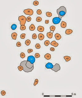
A concentration of pits in a very small area was excavated at Outeiro Alto 2. The concentration was generically circular (Figure 1). 

Figure 1

The pits were all almost empty of archaeological material. In the periphery there were three Late Neolithic hypogea and a grave pit (Figure 2).

Figure 2

To try to understand the concentration of pits in this small area, with no overlaps and surrounded by tombs, a study of the morphology and volumes of the pits was done. It was possible to cluster the pits in three groups of sizes and deepness (Figure 3).

Figure 3

When those clusters were plotted in the plan, a pattern emerged (Figure 4): the deepest pits formed a circle with a square in the centre and two pits towards north; then surrounded by the smallest pits; and the intermediate pits scattered in the SW area. 

Figure 4

The distribution, the size of the central pits and the absence of archaeological material inside them (just two or three small shards of pottery) clearly suggest a circular wooden structure of henge type surrounded by the tombs.


This context is published here: Valera & Filipe,2012

Wednesday, October 16, 2013

0211 - Wood constructions

 I have been suggesting that we have several evidences of wood constructions in portuguese prehistory that could be similar to some wood henges or palisades of Europe. One of those evidences is the area C of Outeiro Alto 2 (Valera e Filipe, 2012 pdf). I will talk here about that in the next post.

Today I present the strange case under excavation (by Omniknos/Era): 145 pits, with no archaeological material inside, very close to each other, but with no overlaps, producing several aligned rows. They are clearly for large posts (trunks) and do not define a circle, but an elongated area, partially curved. In the outside curved row an interruption is visible and might correspond to a passage.


This is a very strange context. If it is prehistoric (there are several prehistoric contexts nearby), it reinforces the idea that many pits are post holes and that we have to have notion of their spatial distribution to detect the kind of structures they belong to (as it happened at Outeiro Alto 2).


Detail of the outside curved row of pits

Monday, October 14, 2013

0210 – Causewayed enclosures in Portugal?

Causewayed enclosures are a typical site from British islands prehistory. However, a recent publication shows the presence of what we should call causewayed enclosures in Iberia, in Northern Meseta (García García, 2013).

Image taken from García García, 2013.

Well, at Herdade do Estácio (Beja), a site being excavated by Omniknos Company (direction of Tiago do Pereiro) a sequence of elongated pits were recorded and they clearly remind the same general plan of a causewayed feature. The materials collected inside the pits indicate a Late Neolithic chronology. The layout and the chronology reminds the enclosure of Fareleira 3, although the ditches are bigger there.


Late Neolithic causewayed feature (?) at Herdade do Estácio. 

This empirical data is scarce at the moment, but starts to suggest that, once again, we might have in Iberia elements that clearly integrate the peninsula in phenomena of European scale.


References:
García García, M. (2013), “Las Pozas (Casaseca de las Chanas, Zamora): dos nuevos recintos de fosos calcolíticos en el Valle del Duero”, Trabajos de Prehistoria, 70:1, p.175-184.

Saturday, October 12, 2013

0209 – Updating Coelheira 2/3

The sections are almost excavated. The ditches sizes and fillings suggest they are palisade ditches. But the interesting thing is that it is not one enclosure with two ditches, as previously suspected, but two enclosures side by side, just a few meters distant from each other.


Enclosure A.


Enclosure B. The two sections excavated. In the right one we can see an interruption corresponding to a gate, as usually facing east.

Thursday, October 3, 2013

0208 – The Santa Sofia Chalcolithic ditch

Prehistoric sites with ditches are still rare in Portuguese Estremadura. So far we had notice of a small ditch in Mafra municipality (Gonçalvinhos), with an uncertain chronology. Recently a new site with a ditch was published (Pimenta et al, 2013): it is the site of Santa Sofia, in Vila Franca de Xira.

Under a complex occupation of the Late Bronze Age (and following historical periods) a ditch section was discovered and dated by radiocarbon and archaeological material from the Chalcolithic.

Although the characterization of this context is still limited, its discovery is of extreme importance because it documents the presence of these kind of structure in the Estremadura Chalcolithic where, so far, only walled enclosures were known. We will be waiting for the detailed publication of this new ditch context.


Ditch plan under later hut structures and ditch section (image taken from Pimenta et al, 2013)

References:

Pimenta, J., Soares, A.M. e Mendes, H. (2013), "Cronologia absoluta para o povoado Pré-Romano de Santa Sofia (Vila Franca de Xira)", Cira_Arqueologia, II, p.181-194.