Sunday, December 29, 2013

0235 – Enclosures in 2013


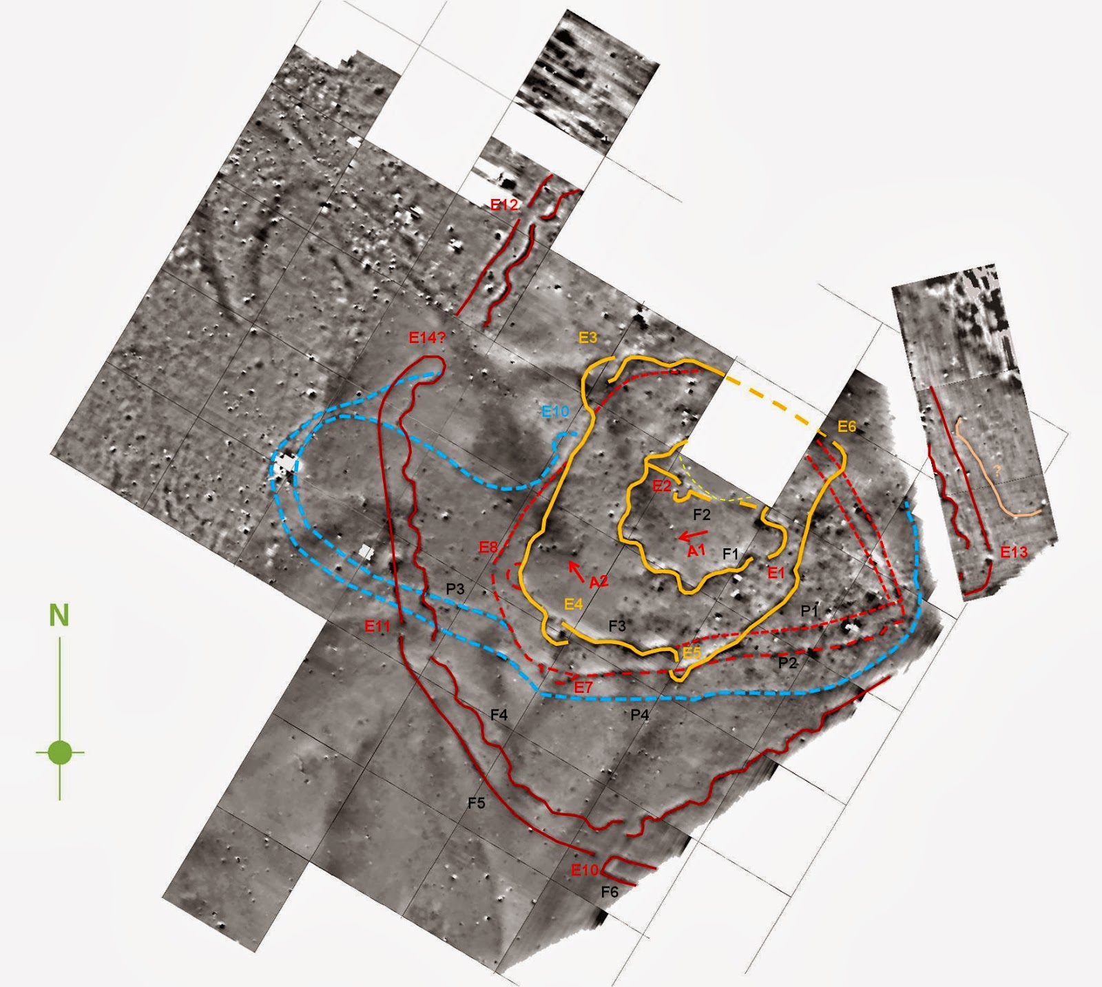
Central area of the complex of encosures of Monte da Conteda (magnetogram from Helmut Becker). A very complex site, with more than 20 ditched enclosures with very different layouts and chronologies. 

In the 1st of January of 2013 I wondered if this year would be a good year for Portuguese Prehistoric enclosures research. And it certainly was so. Apart from the development of research project and rescue excavations on sites already known, this year saw the discovery of several new enclosures in Alentejo hinterland. Monte das Cabeceiras 2, Herdade da Corte, Monte da Contenda, Figueira, Borralhos, Folha do Ouro 1, Nobre 2, Lobeira de Cima, Coelheira 3, Montoito are ten new enclosures detected in 2013.
Eight of them were discovered in the context of a research program and two were already submitted to geophysical prospection with very good results.

In a time of decay of the investment in archaeological research in Portugal, these results, for Alentejo’s Recent Prehistory, are not bad at all.

Monday, December 23, 2013

0234 – Barranco de Rio Seco 4 ditched enclosure

Location: Ferreira do Alentejo municipality, Beja district, Alentejo, South Portugal)
Chronology: Late Neolithic or Chalcolithic
Bibliographic references: (Neves et al., 2013)


Ditch from Barranco de Rio Seco 4 (after Neves et al., 2013)

Surveyed in the context of Edia water supply network, this site presents a small ditch with 1m wide and 0,90m deep, associated (as usual) to several pits. The authors attribute these contexts to Chalcolithic, although the pottery collected does not present a clear chronological ascription: the described pottery shapes could also be present in a Late Neolithic context.
It might be another small enclosure, like others identified in the region, like Muteira 6 or Coelheira 3.

References:

Neves, C.; Martins, A.; Andrade, M.; Pinto, A. e Magalhães, B. (2013), “Estratégias de povoamento das comunidades do Neolítico Final e Calcolítico no Vale da Ribeira do Alfundão (Ferreira do Alentejo, Portugal)”, Arqueologia em Portugal – 150 anos. Actas do I Congresso da AAP, Lisboa, AAP, p.361-372.

Saturday, December 21, 2013

0233 – Winter solstice day

To celebrate the winter solstice day here are two Portuguese ditched enclosures that, some 4,5 thousand years ago, commemorated this solar event through their architecture. Both have their gates orientated to the sun rise at this particular day.


Xancra (Cuba, Beja).


Outeiro Alto (Serpa, Beja)

 Natal is rooted in quite earlier times…


Thursday, December 19, 2013

0232 - New blog on Perdigões enclosure


Dedicated to the Perdigões Research Program: http://perdresearch.blogspot.pt/.

0231 - Quinta da Fé (a new ditched enclosure ?)


Location: Vidigueira municipality, Beja district, South Portugal)
Chronology: Unknown
Bibliographic references: Unpublished.

Discovered on Bing Maps! Apparently Google Earth is not the only tool to find new enclosures.
This one appears to be circular in shape, with a lobule heading southwest, resembling another enclosure, namely Outeiro Alto 2 (Valera & Filipe,2010; Valera et alli, 2013), although Outeiro Alto’s faces southeast.
 Measuring approximately 77 meters maximum diameter, it seems to be a double enclosure – the inner ditch measuring approximately 20 meters diameter.

It is interesting to notice the fact that the site is located at about 500 meters from the well-known pre-historic site of Mangancha (Gonçalves, 1994).

References:
GONÇALVES, V.S. (1994) - Distrito de Beja, Vidigueira : Monte da Mangancha. Informação Arqueológica. nº 9 (1994). p. 109-110
VALERA, A.C.; FILIPE, V. (2010) – O Outeiro Alto 2 (Brinches, Serpa): Nota Preliminar sobre um Espaço Funerário e de Socialização do Neolítico  à Idade do Bronze. Apontamentos de Arqueologia e Património.nº5 (2010). p. 49-56
VALERA, A.C.; FILIPE, V.; CABAÇO, N. (2013) - O Recinto de Fosso de Outeiro Alto 2 (Brinches, Serpa). Apontamentos de Arqueologia e Património.nº9 (2013). p. 21-35

By Rui Godinho

Monday, December 16, 2013

0230 – “Drawing” ditched enclosures

The idea has been suggested earlier by others, but was stressed again recently by Coimbra (2013): some concentric circles present in rock art may represent the depiction of enclosures. In this case, the rock 132 from Fratel (middle Tagus river, central Portugal) really resembles a ditched enclosure with a gate with its “crab pincers”, reminding Perdigões outer gates, Xancra or many others from France.


(image taken from F. Coimbra, 2013, Ruptejo. Arqueologia rupestre da bacia do Tejo)


Gate 2 of Perdigões


Enclosure of Chez-Reine (France)

As I put it recently, a same general idea can be expressed in an architectonic design, in a decoration of a pot, in pattern of a textile, in a motive of an art composition. Does this particular association of the motive on rock 132 to an enclosure depiction makes sense? Why not?

Sunday, December 15, 2013

0229 – A glimpse into Montoito

The results of Montoito geophysics are very good and confirm entirely the presence of a ditched enclosure. Well, in fact they are at least three enclosures. The inside is a wavy one, surrounded by two concentric ones. For the moment, here is a glimpse of one gate in the southeast side of the outer ditch (smiling).


A gate that reminds the gates of the outside ditch of Perdigões and the inner gates of Xancra (see here).

The geophysics are from Helmut Becker, done in the context of the NIA-Era project on ditched enclosures plans and orientations directed by me (and with the participation of Tiago do Pereiro, that detected this enclosure in Google Earth).

Monday, December 9, 2013

0228 - Monte da Contenda may have begun in Neolithic

After the first campaign of geophysics at Monte da Contenda (where we discovered that the site is much bigger than previously suspected), we started to clean the section made by the road that cut several ditches (in the context of the project of Nia-Era to define and characterize plans of ditched enclosures). Today we just roughly defined the section of one of the outer ditches of the concentric set of ditches that we can see in the geophysics (but others run outer of this one). 


It needs a better definition of the profile, but it is about 1,20 / 1,50 meters deep and about 2 meters wide (difficult to define since the ditch was cut in the diagonal).


But what is more interesting is that the provided materials suggest a Neolithic chronology (until now, the surface material pointed to an exclusive Chalcolithic chronology), and maybe not a recent one: pot rims are mainly from globular bowls, with walls “almagradas” (a red/orange clayish layer in the pot walls). There is a lot of faunal remains that will allow radiocarbon dating.

If this chronological attribution is correct, than the site would have begun in Neolithic times and it would have been big since the beginning. In fact, it would be the biggest Neolithic ditched enclosure with its plan know in southern Portugal.


We shall see. This is, in fact, a quite promising site.

Thursday, December 5, 2013

0227 - Montoito is (partially) done

We finished yesterday this year campaign of geophysics at the ditched enclosure of Montoito, just 8 klms north of Perdigões. 


Cleaning the field so Helmut Becker could measure was a hard task. 


I would like to thank Rui Mataloto and the Municipality of Redondo for their support and also to the volunteer students of FLUL that collaborated in this arduous ”archaeological” task. Without these collaborations the work simply couldn’t have been done.


Now we just have to wait for the first layout of the measured area to confirm that our “google eye” is sharp. 

Tuesday, December 3, 2013

0226 - A glimpse into Monte da Contenda

Monte da Contenda is much bigger and complex than we expected. The image suggests several enclosures with ditches and palisades, sometimes overlapping and with several going out of the surveyed area, announcing a quite large enclosure (about 300 or 400 meters diameter). There are linear wavy designs and the number of enclosing structures is bigger than in Perdigões. It is another amazing site and more food for thought about Portuguese Ditched Enclosures. And it shows that we are doing a good job with the identification of enclosures through Google Earth.


Part (about ¼) of the magnetogram of Monte da Contenda done by Helmut Becker in the context of the NIA project on ditched enclosures directed by me (it is raw data, steel needing a lot of work from Helmut to produce a clearer image of the enclosures).

Saturday, November 30, 2013

0225 - Monte da Contenda is done

Measuring Monte da Contenda 

The geophysics of Monte da Contenda had just been done. A project of NIA-ERA Arqueologia, directed by me and with Helmut Becker responsible for the geophysics, as usual. The results, I've just been told, are very interesting. Next week, if possible, we will be doing Montoito, just 8 klms north of Pedigões.


Monday, November 25, 2013

Sunday, November 24, 2013

0223 – Ditched enclosures at the VII EASP

At the VII Meeting of Iberian Southwest Archaeology, that will take place next week in Aroche (Spain) and Serpa (Portugal), I (together with Tiago do Pereiro) will be presenting a paper on two ditched enclosures: Monte das Cabeceiras 2 and Salvada.

The paper will be focus on the fact that these two quite similar enclosures are relatively big (Salvada with 17,4 ha and Monte das Cabeceiras with 8,2 ha), probably contemporaneous for a large period of time and surprisingly near to each other (just 3,5 km apart).


We will be stressing the similarity of layouts and the proximity in time and space, in order to question some axiomatic ideas about size and social roles of large enclosures in South Iberia.

Thursday, November 21, 2013

0222 - Geophysics at Monte da Contenda

Next week, a project of NIA-ERA coordinated by me will promote a geophysical survey at Monte da Contenda, one of the sites located in Google Earth and presented in the poster of the previous post. The geophysics will be done by Helmut Becker, as usual. Expectations are high.


Aerial image of Monte da Conteda ditched enclosures. Now we are going to try to get a better image of what is there.

Monday, November 18, 2013

0221 - Poster on ditched enclosures found in Google Earth

Presented to the I Congress of the Portuguese Association of Archaeologists...


See here

Sunday, November 17, 2013

0220 – Juromenha 1 ditched enclosure

Location: Alandroal municipality, Évora district, Alentejo, South Portugal)
Chronology: Late Neolithic
Bibliographic references: (Calado e Roque, 2013)

The ditched enclosure of Juromenha 1 was detected and surveyed in the context of the Alqueva dam mitigation process, in the early XXI century. The survey revealed a plan that suggests a wavy sinuous ditch, with a linear one running parallel. 


Plan of Juromenha 1 (after Calado e Roque, 2013)

The sinuous ditch has a “v” profile, with 2 meters wide and 1,8 meters deep. Four radiocarbon dates put this ditch between 3400-2900 BC.


Ditch section (after Calado e Roque, 2013)


If wavy ditches became more frequent in the 3rd millennium BC in Alentejo, Juromenha 1 clearly shows (as Águas Frias and Ponte da Azambuja also do) that this design emerged in a Neolithic context, where we must search for the reasons that will allow us to explain and interpret these layouts. And not in the chalcolithic walled bastions, as once was supposed.

Friday, November 15, 2013

0219 – Dating ditched enclosures

The number of ditched keeps increasing in Portugal (namely in the South). Having a good chronology of these sites is crucial for the understanding of their emergence, development and fall. I have registered know almost sixty in Portugal, but just 1/6 has been dated by radiocarbon.


Chronology of ditched enclosures of Recent Prehistory in Portuguese territory.

Next week, in the first Congress of the Portuguese Association of Archaeologists I will be presenting a paper that does the synthesis of the available radiocarbon dating information for these enclosures and, based on that, it will be underlined the main tendencies that can be perceived in these architectures during the Neolithic and Chalcolithic.


 Since the proceedings will be released during the congress, the paper will be available by the end of next week. 

Monday, November 11, 2013

0218 - Timber circles (?)

More timber circles at Alentejo? Or just circles made of pairs of pits? Or just coincidences?


Saturday, November 2, 2013

0217 – Almadan #18


The journal Almadan has just been published. Public presentation was today.

Inside there is a paper of mine making a synthesis (a discourse for specialists but also for general public) of the “state of the art” regarding prehistoric ditched enclosures in Portugal: a historical review of the research and dynamics of discovery, an evaluation of interpretative discourses, a censure of some situations regarding preservation and some notes on the potential for public display. 


Wednesday, October 30, 2013

0216 - Communicating interpretations

I come back to Santa Vitoria virtual reconstitution.


I definitely do not agree with it. There is no evidence of a bank inside the ditch. If there was a bank, some pits would have been covered by it; the inside area would have been highly restreated and, most important, there would have been evidences of erosion inside the ditch from a bank built with the geological material. Instead, we have inside the ditch layers of structured depositions and occupation features.

But my point here is that the impact on public opinion of words and pictures is not the same. I want to argue that drawing a scene is more powerful than just describe it by words. Our society is, more than ever, dependent on visual senses. It is easier to memorize an image than a written discourse.

That should give a higher sense of responsibility to the visual reconstitutions of archaeological sites, and in this particular context, of ditched enclosures. What might be presented as hypothesis in discourse seems to be a certain fact when presented in a drawing or animation.

In time, written things became more valued than spoken ones. Today images seem to have a lead. And where discourse might face a doubt, image tends to receive uncritical adherence.  

I don’t know if the readers of this blog agree with this, but I think that we should have this in mind when we decide to use visual representations of our ideas for these prehistoric sites (or any other sites).

Monday, October 28, 2013

0215 – Contenda and Santa Vitória

The recently discovered ditched enclosure of Monte da Contenda (Valera and Pereiro, 2013) through Google Earth, just 4,5 km from Santa Vitória ditched enclosure, raises some interesting questions, just like other enclosures that have been recently identified closer to each other (I remember the case of Salvada and Monte das Cabeceiras 2).

Monte da Contenda has at least three ditches, probably of patterned sinuous design, just like Santa Vitoria. It is in a slope facing south. And behind that horizon is Santa Vitoria.

Monte da Contenda, facing its southern horizon.

Naturally, the same circumstance can be perceived from Santa Vitória: Monte da Contenda is just behind that northern horizon.

Santa Vitória facing its northern horizon

The proximity between these two ditched enclosures, although with no direct inter visibility, needs to be explained. They seem to be contemporaneous (at least in part).

This is a new problem to deal with in Alentejo: the spatial proximity of so many ditched enclosures that seem to be generally contemporaneous (a problem long addressed in European contexts). If they are not, well, than we have to deal with short leaving sites. Which raises other problems to the traditional discourse (and again, not a problem unknown in Europe).

We are arranging things to do geophysics at Monte da Conteda. We hope to get new data to address these problems in a more solid way.

References:

Valera, A.C. and Pereiro, T. (2013), “Novos recintos de fossos no sul de Portugal: o Google Earth como ferramenta de prospecção sistemática”, Actas dos I Congresso da Associação dos Arqueólogos Portgueses, p.345-350.

Wednesday, October 23, 2013

0214 - Two different overlapping enclosures at Moreiros 2?

This is what the geophysics interpretation might suggest. 


General interpretation of Moreiros 2 geophysics (magnetogram from Helmut Becker)


A first one (A) presents mainly palisade structures and has a more irregular design, following the layout of topography.

A second set of enclosures (B), partially overlapping the first, is characterized mainly by ditches, with patterned features (namely gates) and with different designs, more concentric and that don´t respect the topographical layout.


The two possible sets of enclosures.

The two inner ditches of this second sequence (the only ones archaeologically excavated, have been dated from Late Neolithic. That means that the first sequence of enclosures is earlier, maybe from a middle Neolithic. To be true, that would take back a little the emergence of enclosure in Alentejo (as it happens in central Portugal with Senhora da Alegria enclosures).

It would also be interesting to date the outside ditches of the second sequence, the ones that have a sort of polygonal design, for the only parallel we have for that layout is in Chalcolithic walled enclosures (S. Pedro, Porto das Carretas).

This data and ideas were published in:

António Carlos Valera, Helmut Becker e Rui Boaventura
MOREIROS 2 (ARRONCHES, PORTALEGRE): GEOFÍSICA E CRONOLOGIA DOS RECINTOS INTERIORES, Apontamentos de Arqueologia e Património, 9.

 Download HERE.

Tuesday, October 22, 2013

0213 - New number of AAP journal


 Volume 9 of the journal Apontamentos de Arqueologia e Património has been published. In this volume there are seven papers related to four Portuguese ditched enclosures: Perdigões, Porto Torrão, Outeiro Alto 2 and Moreiros 2. Free download here.

Here are the references:

António Carlos Valera
CRONOLOGIA ABSOLUTA DOS FOSSOS 1 E 2 DO PORTO TORRÃO E O PROBLEMA DA DATAÇÃO DE ESTRUTURAS NEGATIVAS “TIPO FOSSO”

Randi Danielson e Patrícia Marques Mendes
POLLEN ANALYSIS OF LATE NEOLITHIC DITCH DEPOSITS FROM THE PERDIGÕES ARCHAEOLOGICAL SITE

António Carlos Valera, Victor Filipe e Nelson Cabaço
O RECINTO DE FOSSO DE OUTEIRO ALTO 2 (BRINCHES, SERPA)

António Carlos Valera, Helmut Becker e Rui Boaventura
MOREIROS 2 (ARRONCHES, PORTALEGRE): GEOFÍSICA E CRONOLOGIA DOS RECINTOS INTERIORES.

Lucy Shaw Evangelista e Ana Maria Silva
TOMB 3 - PERDIGÕES PREHISTORIC ENCLOSURE (REGUENGOS DE MONSARAZ, PORTUGAL): FIRST ANTHROPOLOGICAL RESULTS.

Lara Milesi, José Luis Caro y Juan Fernández
HALLAZGOS SINGULARES EN EL CONTEXTO DE LA PUERTA 1 DEL COMPLEJO ARQUEOLÓGICO DE PERDIGÕES, PORTUGAL

J. E. Márquez-Romero, José Suárez Padilla, Elena Mata Vivar, Víctor Jiménez-Jáimez, J. L. Caro Herrero y Pablo Cuevas Albadalejo
ACTUACIONES ARQUEOLÓGICAS REALIZADAS POR LA UNIVERSIDAD DE MÁLAGA EN EL YACIMIENTO DE PERDIGÕES (REGUENGOS DE MONSARAZ, PORTUGUAL). TRIENIO 2011-2013

Friday, October 18, 2013

0212 – A wood henge at Outeiro Alto

A concentration of pits in a very small area was excavated at Outeiro Alto 2. The concentration was generically circular (Figure 1). 

Figure 1

The pits were all almost empty of archaeological material. In the periphery there were three Late Neolithic hypogea and a grave pit (Figure 2).

Figure 2

To try to understand the concentration of pits in this small area, with no overlaps and surrounded by tombs, a study of the morphology and volumes of the pits was done. It was possible to cluster the pits in three groups of sizes and deepness (Figure 3).

Figure 3

When those clusters were plotted in the plan, a pattern emerged (Figure 4): the deepest pits formed a circle with a square in the centre and two pits towards north; then surrounded by the smallest pits; and the intermediate pits scattered in the SW area. 

Figure 4

The distribution, the size of the central pits and the absence of archaeological material inside them (just two or three small shards of pottery) clearly suggest a circular wooden structure of henge type surrounded by the tombs.


This context is published here: Valera & Filipe,2012

Wednesday, October 16, 2013

0211 - Wood constructions

 I have been suggesting that we have several evidences of wood constructions in portuguese prehistory that could be similar to some wood henges or palisades of Europe. One of those evidences is the area C of Outeiro Alto 2 (Valera e Filipe, 2012 pdf). I will talk here about that in the next post.

Today I present the strange case under excavation (by Omniknos/Era): 145 pits, with no archaeological material inside, very close to each other, but with no overlaps, producing several aligned rows. They are clearly for large posts (trunks) and do not define a circle, but an elongated area, partially curved. In the outside curved row an interruption is visible and might correspond to a passage.


This is a very strange context. If it is prehistoric (there are several prehistoric contexts nearby), it reinforces the idea that many pits are post holes and that we have to have notion of their spatial distribution to detect the kind of structures they belong to (as it happened at Outeiro Alto 2).


Detail of the outside curved row of pits

Monday, October 14, 2013

0210 – Causewayed enclosures in Portugal?

Causewayed enclosures are a typical site from British islands prehistory. However, a recent publication shows the presence of what we should call causewayed enclosures in Iberia, in Northern Meseta (García García, 2013).

Image taken from García García, 2013.

Well, at Herdade do Estácio (Beja), a site being excavated by Omniknos Company (direction of Tiago do Pereiro) a sequence of elongated pits were recorded and they clearly remind the same general plan of a causewayed feature. The materials collected inside the pits indicate a Late Neolithic chronology. The layout and the chronology reminds the enclosure of Fareleira 3, although the ditches are bigger there.


Late Neolithic causewayed feature (?) at Herdade do Estácio. 

This empirical data is scarce at the moment, but starts to suggest that, once again, we might have in Iberia elements that clearly integrate the peninsula in phenomena of European scale.


References:
García García, M. (2013), “Las Pozas (Casaseca de las Chanas, Zamora): dos nuevos recintos de fosos calcolíticos en el Valle del Duero”, Trabajos de Prehistoria, 70:1, p.175-184.

Saturday, October 12, 2013

0209 – Updating Coelheira 2/3

The sections are almost excavated. The ditches sizes and fillings suggest they are palisade ditches. But the interesting thing is that it is not one enclosure with two ditches, as previously suspected, but two enclosures side by side, just a few meters distant from each other.


Enclosure A.


Enclosure B. The two sections excavated. In the right one we can see an interruption corresponding to a gate, as usually facing east.

Thursday, October 3, 2013

0208 – The Santa Sofia Chalcolithic ditch

Prehistoric sites with ditches are still rare in Portuguese Estremadura. So far we had notice of a small ditch in Mafra municipality (Gonçalvinhos), with an uncertain chronology. Recently a new site with a ditch was published (Pimenta et al, 2013): it is the site of Santa Sofia, in Vila Franca de Xira.

Under a complex occupation of the Late Bronze Age (and following historical periods) a ditch section was discovered and dated by radiocarbon and archaeological material from the Chalcolithic.

Although the characterization of this context is still limited, its discovery is of extreme importance because it documents the presence of these kind of structure in the Estremadura Chalcolithic where, so far, only walled enclosures were known. We will be waiting for the detailed publication of this new ditch context.


Ditch plan under later hut structures and ditch section (image taken from Pimenta et al, 2013)

References:

Pimenta, J., Soares, A.M. e Mendes, H. (2013), "Cronologia absoluta para o povoado Pré-Romano de Santa Sofia (Vila Franca de Xira)", Cira_Arqueologia, II, p.181-194.

Friday, September 27, 2013

0207 – Ditches and palynology

Ditches are very interesting contexts for pollen analyses in Alentejo (a dry area, and therefore not very good for pollen preservation). Ditches can perverse humidity, helping the preservation of pollen.

In Perdigões, after a first study done by Jane Wheeler (Wheeler, 2010)  we applied for these analyses through the Portuguese Laboratory of Archaeosciences (LARC) that initiated a new program of scientific cooperation with the National Archaeological community in 2012. For that a specific project was elaborated: “Reconstitution of paleo-environments in Perdigões area.”

The collected samples in the excavations of 2012 were already processed and the results are in press in the journal Apontamentos de Arqueologia e Património that will be published next October 2013, being authors Randi Danielsen and Patrícia Marques Mendes.

Sampling in ditch 6

They refer to the Neolithic contexts of Perdigões and provide a quite relevant information about the landscape flora of the period in the surroundings of the site.


Diagram of results from Randi and Mendes, in press. 


In 2013 we continue to developed the project and new sampling was made, now integrating Chalcoltic contexts. We hope to get a good picture of the evolution of local landscape during the late fourth and 3rd millennium BC and provide empirical data that help in the interpretations of the human occupations and activities in this region.

2013 sampling in the Late Neolithic hypogeum structure

Bibliographic References:

Daneilsen, R. and Mendes, P.M. (in press), “Pollen analysis of Late Neolithic ditch deposits from the Perdigões archaeological site”, Apontamentos de Arqueologia e Património, ), Lisboa, NIA.ERA, p.13-20.


Wheeler, Jane (2010), "Paleoenvironmental assessment of two archaeological sediments from Perdigões, Alentejo region, Portugal", Apontamentos de Arqueologia e Património, 6, Lisboa, NIA-ERA Arqueologia, p.41-45.

Wednesday, September 25, 2013

0206 – Debating ditch fillings and ditch excavations.

Interpretation of ditch functions depends a great deal on what we find inside them. And what we find inside them depends a great deal on the way we excavate them.

Ditch 8 of Perdigões is a good example of these two circumstances.

First let’s look to what we find inside the ditch. The top of the ditch filling was exposed in a 12m area. It showed a deposit covered by a central concentration of fragments of pottery. Removed that first layer of pottery another one appeared. Just like ditch 12, Late Neolithic ditch 8 had its top filling layers incorporating an “avenue” of pottery shards (Figure 1).


Deposition of pottery shards in the top of ditch 8 of Perdigões (taken from the report of 2013 excavations)

But the section that we have done in the ditch showed that this horizontal depositions of pottery, stones and faunal remains continue in depth. If we look to the plans of this section (figure 2) we will see that there are layers of depositions of those material intermediating with layers of just earth, until the bottom part of the ditch, where this kind of depositions became continuous.

Plans of the stratigraphy f the section excavated in ditch 8 (taken from 2013 report)


So, ditch 8 was filled with layers of intentional horizontal depositions of selected materials (fragments of pottery, faunal remains and stones), in an intermittent rhythm. This stratigraphy is not coherent with draining or defensive functions. It clearly shows that there was an intentional filling that went on in an intermittent rhythm, providing horizontal layers. The intermittence suggest that these practices of intentional deposition were intermittent themselves. That they were periodical.

The sections of a 1,5m deep ditch and the definition of the top layers of pottery depositions took us two campaigns (one month each) to achieve.

The second issue that I want to address is: why this kind of depositions are not occurring in other ditch enclosures excavated in Portugal? Are they a particularity of Perdigões? Perhaps they are. But one thing I am convinced: the actual practices of excavations in rescue archaeology would not be able to detect these depositions. When you have to excavate a ditch and get paid 55€ a square meter (independently of the depth), then you have to be satisfied if a rough image of the stratigraphy is obtained. Archaeology of negative structures is progressively becoming the activity of quickly emptying pits and ditches.

So what empirical record will we have to deal with in our debates, theoretical hypothesis and social-historical problems? What is being rescued? Does it worth what it costs?  

The problematic of ditch enclosures is not just about understanding Prehistoric communities. Is also about understanding our own society, and why we do what we do.